| |
|
|
|
|
| |
|
|
||
| |
||||
| |
|
|||
| |
|
|||
An estimated one-third of the world's remaining temperate rainforests is found in southern Chile and Argentina. Considerable public and private will exists to safeguard the extraordinary biodiversity found in these forests, especially as threats increase. If predictions hold true, Chile will become the second-largest exporter of wood, cellulose, wood chips, and other forestry products in the Southern Hemisphere. It now holds fourth place.
Chile has 32 National Parks, 13 Natural Monuments, and 47 National Reserves, which cover more than 30 million acres. Yet many state lands in Chile are only “paper parks”: the protections are not enforced, making acquisitions such as those coordinated by AFI so necessary. AFI was a key force in kickstarting the movement to acquire and permanently protect critical, threatened forest areas in Chile. When AFI first became involved, Chile had at the most a handful of private parks; now there are more than 140, translating into hundreds of thousands of protected acres.
Cani
 The
Santuario Cañi was AFI's first completed acquisition and community-based
native forest project, aided by wildlands philanthropists and the current
title holder, Fundación Lahuen. Officially established in 1992, the
sanctuary is the site of Chile's premiere native forest education project
and is one of its first private parks. It has become a model by actively
promoting environmental education, ecotourism (primarily through the Hostería
¡école!), local guide training, and native plant nurseries
and seed collection as job alternatives to logging for the local campesinos.
To maintain maximum protection, the Cañi does not permit roads, tree
cutting, or permanent structures and only allows human access by foot.
The
Santuario Cañi was AFI's first completed acquisition and community-based
native forest project, aided by wildlands philanthropists and the current
title holder, Fundación Lahuen. Officially established in 1992, the
sanctuary is the site of Chile's premiere native forest education project
and is one of its first private parks. It has become a model by actively
promoting environmental education, ecotourism (primarily through the Hostería
¡école!), local guide training, and native plant nurseries
and seed collection as job alternatives to logging for the local campesinos.
To maintain maximum protection, the Cañi does not permit roads, tree
cutting, or permanent structures and only allows human access by foot.
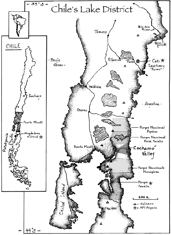
The Cañi is located in Chile's Araucaria Region at the beginning of the Lake District. This 1,200-acre park is the caldera of an extinct Pleistocene volcano. The Cañi is rimmed by rocky promontories and studded with more than a dozen small lakes. Hikers can climb up to the rim (el mirador), where the breathtaking panoramic vista includes four volcanoes (two active), Lake Villarrica, and an extensive temperate rainforest system. The Cañi's primeval forest experience captures the imagination of every visitor.
This relict forest is home to Chile's prized Natural Monument, the araucaria tree (see “Forest Types”). It also provides habitat for pumas, the miniature deer species “pudu,” foxes, black-neck swans, Andean condors, geese, wildcats, Magallanic woodpeckers, hummingbirds, and many other birds, trees, and amphibians. In the spring, the forest floor is covered with beautiful native flowers.
The Pehuenche (People of the Pehuen, the name for the araucaria tree) have lived on this high continental divide for ten thousand years. Their prehistoric relationship with the araucaria tree, central to their cosmology, continues through today. The araucaria forest provides the Pehuenche with great quantities of piñones (pine nuts), a primary source of food and income. AFI channeled funding to the Pehuenche for a new school and cultural center in Quinquen to the north as part of an effort to legitimize their claim to their traditional lands.
 Cochamo
Valley
Cochamo
Valley
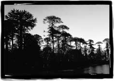
East of Puerto Montt, where the Andes plunge into the Reloncavi Fjord, this 250,000-acre cathedral valley (so-called for both its white granite walls and its towering trees) is one of the last large, undeveloped, and roadless valleys in the region. There is a road to the valley's bottom, and you can take carts all the way up the valley. Since no ferry is needed, it is the only road-accessible fjord still relatively pristine in the upper stretches of the fjord region.
Yet Cochamó Valley was at the point of being pierced by a road and exploited by a logging company when a coalition formed to combat the threat. Community leaders, nonprofits, and funders from Chile and elsewhere came together, with AFI playing a key role. Major elements of the Cochamó community favor conservation and the development of an ecotourism-based economy.
One coalition goal is to purchase two strategic parcels that are key to conserving this magnificent ancient forest watershed. Chilean funders are showing a great deal of interest in the parcels; AFI is still seeking acquisition funding from U.S.-based wildlands philanthropists and foundations. The coalition is also committed to ensuring the ecological continuity of a much larger area, where the Lake and Fjord districts meet.
Few North Americans have heard of the Cochamó Valley. Recently, California's Headwaters Forest was also unknown; indeed, many of the planet's remaining wilderness treasures are unknown. We need to make sure that we don't just learn about them upon their destruction.
Indeed, the Cochamó Valley has been compared to Yosemite in its grandeur and value. Like its California parallel, Cochamó has glistening domes, dazzling waterfalls, and a crystalline, trout-filled river. On the north rim, an old-growth forest of alerce trees (see “Forests Types”), some older than Yosemite's giant sequoias, stands sentinel over the valley below. The potential acquisitions include this forest and a portion of the valley floor, the portal to the granite cathedral within.
If the land can be purchased, the coalition will help strengthen a local
ecotourism and educational project that already has been integrating sustainable
management initiatives into primary forest protection and connection.
The Cochamó Project includes:
- habitat and native forest protection
- native forest education
- appropriate economic development
- wildlife reintroduction
- landscape planning and regional mapping
AFI will continue to raise funds, coordinate project partners, and help the project through to long-term success.
Conservation Geographic Information System (GIS)
The forests of southern Chile have become the focus of an international controversy regarding appropriate management. Several geographic information system (GIS) initiatives in Chile have emerged recently in response to the pressing need to document the breadth and diversity of these forests.
GIS is a computer-based technology used for the storage, management, and analysis of geographic information. The key components of a GIS include software (e.g., ArcInfo and ArcView software by Environmental Systems Research Institute [ESRI], the industry standard) and hardware (e.g., computers, digitizers, plotters, and scanners). Advanced technologies such as global positioning systems (GPS) and satellite imagery have contributed important data for GIS use. Additionally, a robust GIS needs trained human operators.
Networking with other nonprofits, AFI is helping Chile's forest conservation community use GIS efficiently to develop conservation strategies and acquisition priorities. As we have learned in the U.S. forest protection movement, one professional map can be as influential as a year of demonstrations and press releases. It is time to share these lessons effectively with our southern partners.
- Activists equipped with professional maps are needed to stop U.S. and multinational companies from overexploiting Chile's forests, whether those maps are used in court or by newspapers.
- Many in government want to protect Chile's native forests, but need quality information and scientifically based direction to do so.
- Indigenous communities need maps to depict their ancestral homelands and so that they can develop sound management strategies.
In 1998, in conjunction with the Gondwana Forest Sanctuary Campaign, AFI opened Chile's first NGO-based conservation GIS office (in Punta Arenas, within Chile's southernmost region). Many in the Chilean conservation community had been discussing the benefits of GIS, and the idea has spread rapidly. Our effort will work closely with others to enhance conservation GIS opportunities further in Chile, principally by:
- Providing access to free or low-cost state-of-the-art software, with the support of ESRI.
- Offering trainings and volunteer technical GIS expertise, with the support of the Society for Conservation GIS.
- Helping all efforts cooperate for maximum efficiency.
- Continuing to promote use of this technology for the long-term conservation of Chile's forests. (Discussions are also underway to expand this program into Argentina, especially in its section of Tierra del Fuego.)
GIS has the potential to leverage great results in Chile, even beyond what is currently possible here in the U.S. in terms of scope and area of protected forest.
Gondwana Forest Sanctuary Campaign
The Gondwana Forest Sanctuary Campaign, of which AFI is a key participant, was created to protect, reconnect, and restore the Gondwannic life forms and ecosystems by creating an international sanctuary of the Earth's southernmost forests. This all-encompassing sanctuary would protect the temperate rainforests south of 40 degrees south, primarily of southern beech, now imperiled by large-sale commercial logging, wood-chipping, forest conversion, and exports by multinationals.
Gondwanaland was the huge ancient supercontinent joined during the Eocene, juxtaposing South America, Australia, New Zealand, New Britain, Antarctica, New Caledonia, India, New Guinea, and South Africa. The movements of gigantic plates eventually separated these land masses but could not erase what they shared.
Because a majority of the remnant Gondwannic forests are found in Patagonia,
and Tierra del Fuego is home to the southernmost Gondwannic forests in
the world, it was decided in 1998 to begin the campaign there and then
spread northward and outward around the globe, although local efforts
are well on their way in Australia (especially in Tasmania) and New Zealand.
With the Patagonia focus, we especially hope to strengthen the forest
protection movement in Chile, where increasing international pressure
is threatening these temperate rainforests. From these discussions, the
participating organizations and individuals agreed to work cooperatively
to create:
- a geographic information system (GIS) for Tierra del Fuego and Patagonia;
- an international environmental agreement within temperate forest countries to end logging and other industrial activities inside primary forests; and
- the Gondwana Foundation as an institutional entity.
 Chile's
Native Forests
Chile's
Native Forests
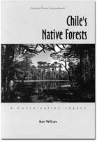
In 1996, AFI published Chile's Native Forests: A Conservation Legacy by Ken Wilcox. This was the first critical overview in print of the state of Chile's extraordinary native forests. The forests of the southern Andes, full of incredibly rare and diverse species, have experienced massive degradation and biotic extinction since the arrival of Europeans. The book has four parts: a discussion of native forests in Chile at the time of conquest, a historical analysis of forest exploitation, an overview of forest conservation during the twentieth century, and a vision for future actions. The English version is available for purchase from AFI; we are in the process of preparing a Spanish version as well.
From the "Foreword"
by Rick Klein, AFI's Executive Director
"At the end of the twentieth century there are few places left in
the world that are still pure. The wild is scarce. The African poet Baba
Dioum said that, "In the end we will conserve that which we love.
We will love that which we understand. And we will understand that which
we are taught." This book shares some of what Chileans and others
have learned about one of Earth's wildest places. It was written to increase
awareness and appreciation for Chile's pristine and exuberant native forests.
"Our greatest common threat today is not nuclear proliferation but rather ecosystem degradation-and its corollary tragedy, species extirpation. As the human population grows, nature is continually degraded and the urgency builds to save what is left, be it seed stock, whales or primary forest. These things are irreplaceable. They are not making any more wilderness…."
From "Part One: Native Forests of Chile"
"That remarkable part of Earth we know as Chile consists of an extraordinary
diversity of environments, from the hottest and driest deserts to the
coolest and wettest rainforests. The country spans nearly 40 degrees of
latitude and more than 7,000 meters (22,800 feet) of vertical relief.
Chile is 4,300 kilometers (2,600 miles) long and barely 160 kilometers
(100 miles) wide, yet its Pacific coastline stretches father than 10,000
km (6,200 miles) from Peru to the southern tip of South America. Two thousand
volcanoes and cinder cones grace the eastern skyline where the crest of
the Andes forms the international boundary with Argentina. If you could
overlay a map of Chile across western North America, it would cover everything
west of the coastal mountain ranges from Acapulco, Mexico, to Ketchikan,
Alaska.
"Within this unique landscape, nature has produced some of the world's most impressive forests. Among them, scarce groves of Chilean palms in the north; the widely distributed (and heavily exploited) southern beech or Nothofagus forests; the distinctive araucaria forests of southern Chile, home to Chile's national tree; and the alerce/southern beech rainforests of the south. The giant alerce or "redwoods of the Andes" is now recognized as one of the largest trees in the world and is the second-most long-lived tree known to botanists (California's bristlecone pine is the oldest)…."
